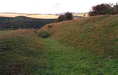
‘Roman genius and energy’: Offa’s Dyke near Edenhope Hill, Shropshire.
In the late 780s Offa took the decision for which he is best remembered: to build the dyke along the Welsh frontier. There had been such dykes before in England, but Offa’s surpassed all these earlier works in scope.
Why did he do it?
Up till now, historians have believed that the dyke was a frontier marker, an agreed boundary between peoples with wide gaps to allow passage on the tradeways from Wales. This view was upheld despite the Welsh chronicles’ record of continuous warfare with Offa, from a battle at Hereford in 760 to one at Rhuddlan in 796. Recent archaeological discoveries have now upturned this interpretation.
We know now that the dyke was not a mere boundary, but a fortified barrier. It was a sharply scarped bank, 25 feet from the bottom of the ditch to the top of the bank, surmounted by a wooden palisade and in some places by a stone breastwork the remains of which were found in the ditch. There may even have been towers. The dyke was also continuous; in the so-called ‘gaps’ or ‘gateways’, where there seemed to be no trace of the earthwork, excavations revealed Offa’s ditch below the present surface. Soldiers, traders and travellers will therefore have passed into Wales through structures which have yet to be identified, fortifications on the dyke, or sally gates.
From the construction techniques, archaeologists have also been able to deduce that the dyke was not built by one great gang, but by many different groups who each dug a few miles. We might connect this with the Tribal Hidage, which lists the peoples who owed Offa military service. Their service could simply have been commuted to work on the dyke, which would then have been built by subject labour, including the men of Wessex, Kent and East Anglia.
Although earlier scholars did not believe that the dyke could have been garrisoned, it is obvious that the labour of manning it would be far less than that of building it in the first place (and it could have been built in one summer). Patrols would have been perfectly adequate if they were linked to the beacon system which was used in Anglo-Saxon times and which survived through the Armada right up to Elizabeth II’s jubilee. The sight lines on some of the central sections of the dyke are nearly twenty miles in either direction, and the beacons could swiftly bring news of a Welsh raid to the assembly points for the local levies. Within hours, hundreds of armed warriors could converge on any trouble spot. Throughout the eighth century the heartland of Mercia had lain open to Welsh incursions. Only fifty years before Offa there had been violent attacks right across to the Fens. Now there was a secure defence.
The most surprising new discovery about the dyke is that it does not run where we thought it did. Three test digs on its presumed northern sector have revealed that there is no evidence that the last twenty miles of the dyke ran through northern Flintshire from Treuddyn to the Irish Sea near Prestatyn. Place-name evidence is unequivocal that a parallel earthwork known as Wat’s Dyke had up to the last century always been called Offa’s Dyke in a major section stretching fifteen miles from the river Alun near Treuddyn up to the river Dee at Basingwerk (a known Mercian fortress). As there is no longer any reason to believe that Offa’s Dyke extended to the Irish Sea, we must now assume that it originally ran near due north to the Dee. In the 890s Bishop Asser said the dyke ran ‘from sea to sea’, but he did not specify its terminations. The later medieval version of the Welsh annals states that in 787
In the summer the Welsh devastated the territory of Offa, and then Offa caused a dyke to be made between him and Wales, to enable him more easily to withstand the attack and that is called glaivd Offa from that time to this day, and it extends from one sea to the other, from the south near Bristol to the north above Flint between the monastery of Basingwerk and Coleshill. Brut y Tywysogion
The line of Offa’s Dyke from the Wye to Treuddyn and then along the northern stretch of ‘Wat’s Dyke’ to Basingwerk fits this description exactly.
‘Roman genius’
To us the vision and confidence which lies behind such a work perhaps smacks of the ideology of the 1000-year Reich. But the man behind it was a military genius with exceptional engineering skill who has rightly been credited with ‘Roman genius and energy’. That verdict has proved all the more true now we know that the models for the dyke were not the great boundary ditches of the continental Anglo-Saxons, but Roman frontier works. Offa need not have seen for himself the Roman northern walls. One of the books we know he possessed (and which was surely read to him) was Bede’s History, where he could find out how to make just such a work, ‘constructed with sods cut from the earth and raised high above ground level, fronted by the ditch from which the sods were cut, and surmounted by a strong palisade of logs. Severus built a rampart and ditch of this type from sea to sea, and fortified it with a series of towers’.
